

4,400 Miles and Counting: How the U.S. Built a Protected Bike Lane Movement
By: Martina Haggerty, Vice President of Infrastructure

Growing from just 24 protected bike lanes nationwide in 2013, this recent estimate reflects decades of advocacy, policy change, and local leadership to give people of all ages and abilities safe, connected places to ride for transportation and recreation.
In 2025, the United States reached a milestone that once felt unlikely: an estimated 4,400 directional miles of protected bike lanes and road-adjacent side paths nationwide, spanning nearly every state. This estimate, developed by PeopleForBikes, is the first recent national snapshot of protected bike lane mileage at scale in the U.S., reflecting decades of advocacy, policy change, and local leadership.
From a Handful of Cities to a National Network
Just a decade ago, protected bike lanes were far from mainstream in the U.S. Today, they’re increasingly common, helping make streets safer and biking a more accessible form of transportation and recreation for people of all ages and abilities.
The growth of protected bike lanes in U.S. cities is closely tied to PeopleForBikes’ origin. In the 1990s, bike industry leaders formed Bikes Belong, which evolved into what is now PeopleForBikes, in an effort to leverage federal funding for the creation of bicycle infrastructure. At the same time, transportation leaders in big cities nationwide were having similar conversations. Those discussions led to the creation of the National Association of City Transportation Officials (NACTO), giving cities a place to learn from one another, push for smarter national policy, and take the lead on how our streets are designed. In 2011, NACTO published the Urban Bikeway Design Guide, a practical manual for engineers to implement safer bike lanes. The guide helped shift protected bike lanes from what some considered “experimental” to a standard practice in communities from coast to coast.
To complement the release of the new guide, PeopleForBikes launched the Green Lane Project in 2012. At the time, protected bike lanes existed in only a handful of U.S. cities: New York, Washington, D.C., San Francisco, and Chicago, among others. In 2013, there were only 24 protected bike lanes nationwide. By 2015, that number grew to more than 270, doubling roughly every two years through 2017.
Turning Lanes Into Networks
As more protected bike lanes were installed, cities shifted their focus from individual projects to fully connected networks that tie into local trails and quieter neighborhood streets, making biking safer and more accessible.
PeopleForBikes tested that idea in 2017 with the Big Jump, working alongside 10 U.S. cities willing to rethink biking at the neighborhood scale. Efforts focused on building connected bike networks that supported daily trips and deepening community engagement, not just installing isolated bike lanes. Cities that followed this approach saw dramatic gains, with local ridership doubling (and in some cases, tripling).
Several years later, through PeopleForBikes’ Final Mile program, cities like Austin and Denver built hundreds of miles of protected lanes and network connections in just three years, more than three times the per-capita rate of comparable cities. In city after city, the pattern was the same.
Across both programs, cities moved faster and built more bike lanes when political leadership, local advocacy, and practical design expertise aligned. Dozens of other U.S. cities followed quickly behind.
Voters also show strong local support year after year, funding the expansion of bike networks by approving more than $49 billion in state and local funding for recreation and active transportation projects since 2019. PeopleForBikes’ VoteForBikes program helps communities turn that support into action by connecting with voters, shaping ballot measures, and securing funding for safer, more connected bike networks.
But protected bike lanes are only part of the story. Thousands of miles of rail-trails, greenways, and mountain bike routes also crisscross the country. The Rails-to-Trails Conservancy estimates that over the past two decades, known rail-trail mileage has grown from about 12,000 miles to more than 25,000, while the broader category of mapped multi-use trails (including rail-trails) expanded from roughly 25,000 miles in 2013 to more than 42,500 miles today. This growth reflects both new trail construction and improved documentation of previously unmapped trails. Linked to protected bike lanes, these trails open the door to more everyday trips, weekend rides, and everything in between.
This same pattern is evident in PeopleForBikes’ annual City Ratings. As protected bike lanes began to link together into real networks, more cities crossed the critical threshold score of 50, the tipping point to becoming a great place to bike. In those places, people can ride to work, school, or daily errands without being forced into dangerous network gaps.
Measuring a Growing Network at a National Scale
With these pieces in place, protected bike lanes spread quickly over the past five years. With that growth came a new challenge: measuring the now thousands of miles of protected bike lanes accurately at a national scale.
Tracking projects by hand was no longer feasible. To solve this issue, PeopleForBikes developed a Protected Bike Lane Inventory in 2025 using OpenStreetMap data and a geometry-based method that distinguishes on-road protected lanes and road-adjacent side paths from off-street trails. By layering map data with spatial factors like road proximity and alignment, this method provides an estimate of protected bike lanes and road-adjacent side paths nationwide. Counting directional miles also helps reflect what riders experience on the ground.
Put together, the data points to about 4,400 directional miles of protected bike lanes across the U.S. as of 2025 — a forty-fold increase since 2000. No dataset captures everything, but this approach comes closer than anything before to showing both how much has been built and where work still needs to be done.
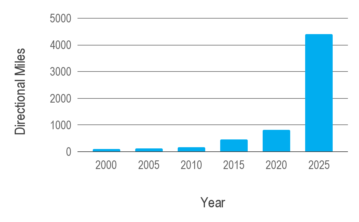
In 2000, there were an estimated 108 directional miles of protected bike lanes in the United States. In 2020, the miles of U.S. protected bike lanes grew to about 800. By 2025, that number was estimated to have grown to approximately 4,400. Directional mileage measures bikeways by direction of travel. If protected bike lanes run on both sides of a street, or if a bi-directional protected lane exists on one side, each direction is counted separately and summed to produce the total mileage.
Anyone can help improve the picture. By updating OpenStreetMap with new protected lanes or adding details like directionality, contributors make it easier to see where networks are growing and where gaps still exist.
Why 4,400 Miles Matters
While 4,400 miles marks real progress, many European cities remain decades ahead. The Netherlands’ bike networks grew out of the Stop de Kindermoord movement in the 1970s, when parents pushed back against streets that had become dangerous for children. In 2007, political leaders in Seville, Spain, committed to building a 50-mile bike network and completed it in under two years. In London and Paris, the Olympic Games created hard deadlines, political will, and funding opportunities that helped both cities quickly build robust bike networks.
The U.S. has taken a longer, more fragmented path. After years of advocacy, connected bike networks are finally taking shape as communities learn to adapt what worked elsewhere to fit their own local politics, street layouts, and funding realities. Programs like the Green Lane Project, The Big Jump, and Final Mile helped translate those ideas into real projects that could succeed in American cities and towns of all sizes.
The results are visible: safer streets, stronger business districts, more transportation choices, and reduced congestion for those who choose to drive.
Looking Ahead
As protected lanes and trails continue to connect into larger systems, this milestone is a starting point for the next phase of work — one focused less on proving the concept and more on getting to work building places where safer, more livable streets are simply the norm.
The cities that continue making progress tend to focus on the same basics: they slow traffic, build protected lanes, fix intersections, and connect gaps to create easily accessible networks.
Trusted data also plays an important role. Cities that track what they’ve built and keep OpenStreetMap data up to date have a much clearer sense of what’s working and where the next investments will make the biggest difference. That combination of design, policy, and feedback is captured in PeopleForBikes’ SPRINT framework.
Cities that get these fundamentals right tend to see the same results: ridership grows faster, public support holds up over time, and biking becomes an option for more everyday trips. The jump to 4,400 miles shows what can happen when those conditions line up.
Every vote, every city plan, and every mapped mile helps the U.S. move closer to the safer streets seen in places like the Netherlands, Seville, and Paris. You can be a part of making biking better for everyone across America by becoming a PeopleForBikes Foundation member. Join us today.
Related Topics:

Take Action
