

New Tool Highlights America’s Most Dangerous Streets for People Riding Bikes
By: Martina Haggerty, vice president of infrastructure
For years, transportation safety advocates have pushed for greater transparency in crash data to better protect people walking and biking. Now, a groundbreaking new platform from The White Line is helping uncover opportunities for safer, more connected streets — making it easier than ever to understand where, how, and why improvements are needed.
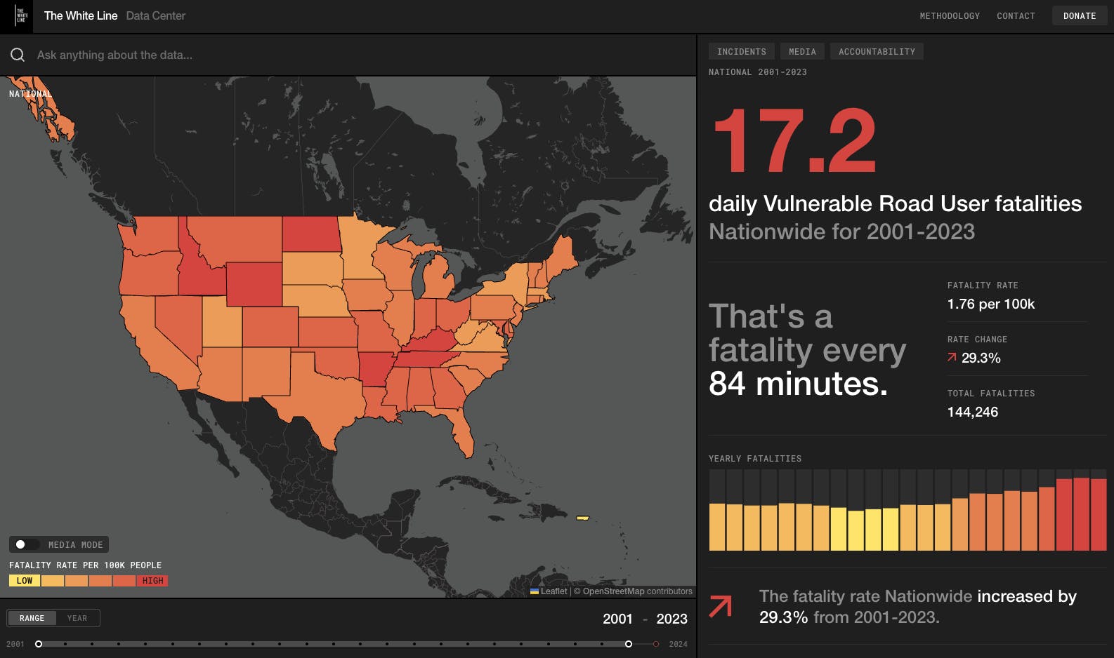
The White Line’s AI-powered platform maps two decades of crash data for people walking and biking, helping communities pinpoint the most dangerous streets and intersections and take action for safer, more connected streets.
In many states, detailed crash data for people walking and biking is scattered, hard to access, or hidden deep within complex government databases. That’s changing with The White Line’s first-of-its-kind, AI-powered platform — a powerful tool for making U.S. streets safer. Using artificial intelligence, the platform compiles decades of fragmented crash records, news coverage, and demographic information, then cleans and analyzes it to reveal powerful insights and patterns that were once out of reach.
The new tool lets users:
- Search and download detailed bike and pedestrian crash data from 2001 to 2024.
- Pinpoint the most dangerous streets and intersections for people biking and walking.
- Track what happens after a crash, including local news coverage, charges filed, and accountability outcomes.
Drawing from more than two decades of national crash data, state records, census information, and news reports, the platform offers an unprecedented, exportable, state-by-state view of road safety across all 50 states.
Reliable, high-quality bike safety data is essential for transforming local advocacy efforts into real improvements. This new platform can help pinpoint where changes are most needed, from protected bike lanes and safer intersections to effective traffic-calming measures. Armed with accurate information, community members can encourage local leaders to take action and make streets safer for everyone.
See how your community stacks up, then take action:
- Check your City Ratings score. Start with PeopleForBikes’ City Ratings to see how your community scores for safe, connected, and comfortable places to ride. Use City Ratings to identify gaps in your local bike network and where improvements will have the most significant impact on connectivity and rider safety.
- Explore crash data. Use The White Line’s interactive crash data mapper to identify the most dangerous streets and intersections in your community.
- Review local planned bike projects. Combine crash insights with PeopleForBikes’ database of planned bike infrastructure projects to build an evidence-based roadmap for change.
- Develop strong talking points. Use insights from PeopleForBikes’ City Ratings and The White Line’s crash mapping tool to create clear, actionable messaging for conversations with local elected officials and decision-makers.
- Engage local leaders. Talk to city and county officials about the data you’ve collected and push for safer, more connected bike networks in your community.
- Stay informed. Sign up for PeopleForBikes’ news and advocacy alerts so you can take action on opportunities to improve bike safety in your area.
Together, we can make the case for better bike infrastructure and save lives.
Related Topics:

Take Action
