

Washington DC: Green lane to connect rail trail with transportation hub
By: David Cranor
Running north from Union Station, 1st Street NE is quickly becoming the main street of one of Washington, DC’s newest neighborhoods, NoMa. Short for “North of Massachusetts,” NoMa has risen from long-ignored former rail yards to become the east end of downtown. In the last decade, the area has added its own Metro station, a grocery store, a mix of residential, office and retail space and the Metropolitan Branch Trail – a unique rail-with-trail that will eventually connect downtown with the Maryland suburbs.
The District’s Department of Transportation (DDOT) is planning a complete reconstruction of 1st Street NE, and that project will replace a bike lane with a green lane, in this case a two-way cycletrack, from Columbus Circle to M Street. Bike lane users frequently find cars parked in the existing bike lane, so the green lane should solve that problem. Mike Goodno with DDOT notes that the green lane “is essentially the southern terminus of the Met Branch Trail. It is highly unlikely, due to space constraints, that the trail [south of L Street] will ever be off-road.” At Columbus Circle the green lane will connect to the Union Station rail station which serves as the boarding point for Amtrak, the Maryland and Virginia commuter rails and the Metro. It is also the site of DC’s iconic bike station and new bike lanes. On the other end, a quick jaunt down M Street will connect people on bikes to the current entry point to the Metropolitan Branch Trail, and when construction at L and 1st is complete, green lane users be able to connect directly to the trail at a ramp along the north side of L Street.
The cycletrack will not go north of M Street because of parking and hotel drop-off conflicts. People riding south on bikes will have three options for entering the green lane, which will be on the opposite side of the street. They’ll either have to cue up in front of traffic on M St and make an right into the cycle-track, cross as a pedestrian using the crosswalks, or make a vehicular left turn (or and S turn, if you will) and enter the cycle track.
DDOT has not yet decided how to handle turns across the cycle track. They’re analyzing the effects on traffic flow of protected turns and the decision may be influenced by the research they’re conducting on the 15th St cycletrack.
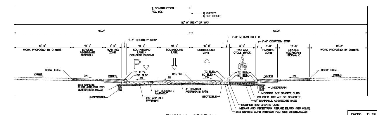
The 8 foot wide cycletrack will be separated from traffic by plastic safe-hit bollards on the southern half, and a raised 1 to 2-foot wide concrete barrier on the north. This will be the first time DDOT uses something other than paint or plastic safe-hit bollards to separate cyclists from traffic – an idea popular in Europe or Montreal, but relatively new to the United States.
The project also represents the first time DDOT has added a green lane that wasn’t part of the 2005 Bicycle Master Plan, showing a willingness to be more ambitious after dramatic growth and unquestioned success.
Though a short facility, it will serve as a key connection between several key elements of the District’s ever-growing bicycle transportation network.

Take Action
